Hello, my name is Rafał and here I’d like to present what I’ve done since last released version of E3Map for Hearts of Iron 2 – new version compatible with Darkest Hour. Last released E3Map version had standard 2608 provinces due HoI2 provinces amount limit set by Paradox, we were not able to make all changes we planned. Since Darkest Hour gave us almost unlimited possibility to edit map (almost – there are still limited amount of provinces allowed to use set to 10000, but I doubt game could handle such number of provinces) I’ve decided not to merge previously split provinces anymore to find free IDs, but and just concentrate on adding provinces where it is needed and make that map much more universal (all XX century wars and border changes should be possible to present). Current map version has 4388 provinces. The map is still under construction and you can see that is unbalanced in many areas – compare Mexico to USA.
Major changes I made (note: province names are from 1936 year):
1. Soviet Union - One of biggest changes were made in Soviet Union for example in Caucasus area (almost all short lived republics should be possible), Trans-Siberian Railway (many new provinces from Moscow to Vladivostok), also ambitions of some east European countries can be now realized for example Ukraine (borders of Ukrainian People's Republic), Belarus (Belarusian ethnic borders) and Cossack States.
2. South America – one of my favorite region in game, but never loved by map makers. As you’ll see it’s probably the most changed region on the map. For example who said Uruguay can’t have 8 provinces or battle ground of Chaco War must be just 1 province, why not 10? Also unstable Amazonian region on Ecuador, Peru and Colombia border has much more provinces and all those countries have crossing claims on each other. Brazil in previous version was a country with just few provinces covering huge territory which you could defend with just few divisions, now it has a lot of new provinces in almost ‘European’ size, bigger only in completely unorganized, sparsely populated areas like Amazonian jungle or northern Mato Grosso.
3. Spain – I tried to allow more or less historical starting positions for both Nationalist and Republican armies in Spanish Civil War.
4. Balkans – there are a lot of new provinces in that area, even some one could say too much, but to represent all major, even not all, territorial changes and claims of all bigger or smaller countries in that area, it was the must. For The Great War Mod Project most important is possibility to represent almost all possible territorial changes during Balkan Wars and the Great War.
5. Turkey and Middle East – More or less I have added all I could add, I still plan to make minor changes in Jordan and the Rub' al Khali (Empty Quarter) region. Probably all Middle East states can have it’s own historical borders now, even short lived Arab States like Asir or Hijaz.
6. Mexico and Central America – A lot of provinces added, Currently you need many divisions to defend Mexico, it also allows much more interesting Mexican Revolution.
7. Japan and Korea – many changes, some provinces may even look like unclickable.
8. Microstates and extra small provinces – Andorra, San Marino, Monaco, Liechtenstein, Vatican are in; Portuguese, French, British or German strategic naval bases in Asia are in too (useful in World War 1 scenario).
9. Many new sea-zones added around America.
To-do list:
1. Provice_names.csv – some land provinces names need to be fixed, almost all sea-zones need to be renamed.
2. Province.csv – seriously everything except positioning (place on the map of armies, navy, ports etc.) and areas/regions.
3. Map – USA and Canada in North America; Africa and South Asia (from Pakistan and Afghanistan on the west to Indonesia); Oceania.
4. AI files – currently AI is rather stupid with all those new provinces.
5. Revolt file – I’ve made a playable revolt file, but it’s based on 1936 situation.
ps. Is it a good time to upload map files now?
E3Map for Darkest Hour
Moderator: mumia
E3Map for Darkest Hour
![]() by mumia » Thu 16. Feb 2012, 22:51
by mumia » Thu 16. Feb 2012, 22:51
- mumia
- Posts: 155
- Joined: Wed 15. Feb 2012, 18:52
- Location: Dąbrowa Górnicza (Zagłębie Dąbrowskie), Poland
Re: E3Map for Darkest Hour
![]() by Arturius » Thu 16. Feb 2012, 23:42
by Arturius » Thu 16. Feb 2012, 23:42
mumia wrote:ps. Is it a good time to upload map files now?
Could you make a list which regions/countries are more or less final so that we are able to start modifying province.cvs (distribution resources, MP, IC etc.)? I would upload your map with my first modified files. Go ahead if you want to release your unmodified E3 map here. Btw, do you have a blank map that you could share with us?
Rafal, you are doing a great job. Your map is one of the reason I never stopped my mod ambitions.
-

Arturius - Administrator
- Posts: 459
- Joined: Wed 15. Feb 2012, 14:20
- Location: Erfurt, Germany
Re: E3Map for Darkest Hour
![]() by Serenissima » Fri 17. Feb 2012, 03:19
by Serenissima » Fri 17. Feb 2012, 03:19
Nice work! I think I like it even better than DH's map.
-

Serenissima - Administrator
- Posts: 40
- Joined: Wed 15. Feb 2012, 17:28
- Location: Durham, United Kingdom
Re: E3Map for Darkest Hour
![]() by mumia » Fri 17. Feb 2012, 14:38
by mumia » Fri 17. Feb 2012, 14:38
Sorry Rafal, I accidenttally edited your post. You have to re-edit again.
OK, it was more or less:
1. Map showing regions in 99% redrawn (red area on that map) and regions which need to be redrawn (orange on that map).
2. Colorscales maps sent via PM.
3. Thank you.
4. E3Map for Darkest Hour:
http://www.mediafire.com/?4i0y8d8yx3cq0bu
- expect AI spamming with militias.
OK, it was more or less:
1. Map showing regions in 99% redrawn (red area on that map) and regions which need to be redrawn (orange on that map).
2. Colorscales maps sent via PM.
3. Thank you.
4. E3Map for Darkest Hour:
http://www.mediafire.com/?4i0y8d8yx3cq0bu
- expect AI spamming with militias.
Last edited by mumia on Fri 17. Feb 2012, 23:01, edited 1 time in total.
- mumia
- Posts: 155
- Joined: Wed 15. Feb 2012, 18:52
- Location: Dąbrowa Górnicza (Zagłębie Dąbrowskie), Poland
Re: E3Map for Darkest Hour
![]() by Arturius » Fri 17. Feb 2012, 15:09
by Arturius » Fri 17. Feb 2012, 15:09
Thank you. Yes please, send me the colorscale layers.
-
Arturius - Administrator
- Posts: 459
- Joined: Wed 15. Feb 2012, 14:20
- Location: Erfurt, Germany
Re: E3Map for Darkest Hour
![]() by Viden » Sat 18. Feb 2012, 22:29
by Viden » Sat 18. Feb 2012, 22:29
Wow! The map looks amazing. I can't wait to see it finished.
-

Viden - Posts: 124
- Joined: Wed 15. Feb 2012, 20:48
- Location: Leipzig, Germany
Re: E3Map for Darkest Hour
![]() by mumia » Sun 19. Feb 2012, 16:24
by mumia » Sun 19. Feb 2012, 16:24
By the way, if any one has any suggestions about map or good map sources, especially for 'orange' not redrawn regions, please post them here. For example I need a source map of Venezuelan territory annexed by Brazil in 1905 (nowadays northern Brazilian Roraima state) or maps of USA and Canada. In USA I would like to know which possible revolters should be possible to release. If you still plan XIX century scenario in future, I'll also need to know what was the situation in Africa, I'm not an expert of XIX century Africa and I don't even know if there still existed any 'uncivilized' state.  If you have any source maps of Australia, New Zealand, Indonesia or New Guinea showing situation in 1936 or older please post them here or send me in PM.
- mumia
- Posts: 155
- Joined: Wed 15. Feb 2012, 18:52
- Location: Dąbrowa Górnicza (Zagłębie Dąbrowskie), Poland
Re: E3Map for Darkest Hour
![]() by Arturius » Sun 19. Feb 2012, 17:17
by Arturius » Sun 19. Feb 2012, 17:17
Africa
Uncivilized states:
http://en.wikipedia.org/wiki/Ouaddai_Empire
http://en.wikipedia.org/wiki/Sultanate_of_Darfur (was a puppet of UK, Sultanate uprised in 1916)
http://en.wikipedia.org/wiki/Dervish_State
http://en.wikipedia.org/wiki/Sokoto_Caliphate (since 1903 puppet)
(Of course Morocco, Ethopia, Senussi Ordre.)


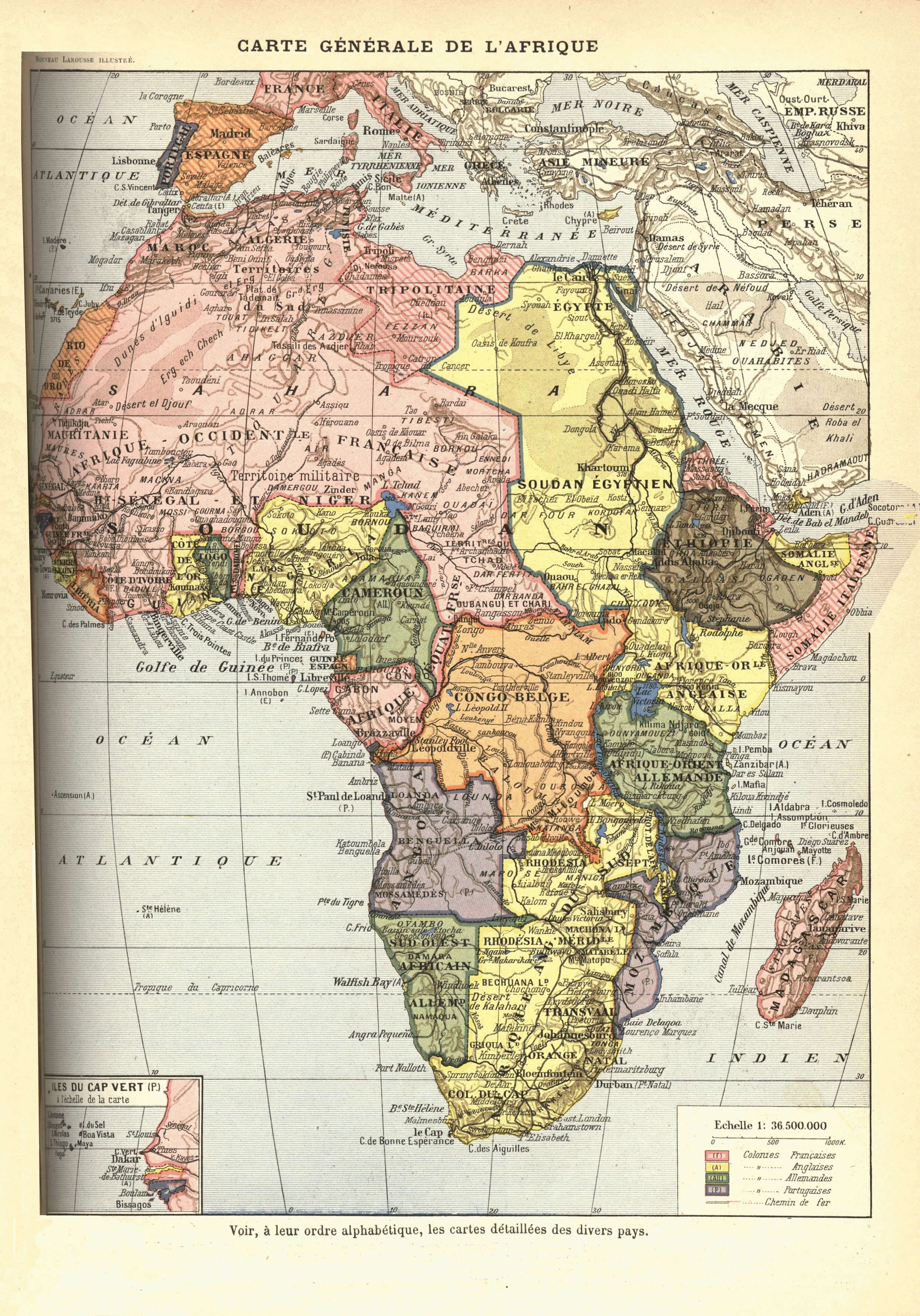
Be aware that Libyan borders were slighlty different:


During Ottoman rule Libya was divided into three subkingdoms (Vilayets): Tripolitania, Fezzan, and Cyrenaica. But cannot find historical map.
Camerun (there was exchange of territories before 1914):


Dafur:

Morocco (was slightly annexed by France):

Notable plans, events, revolters:
Pink Map ()

Fashoda Crisis
Uncivilized states:
http://en.wikipedia.org/wiki/Ouaddai_Empire
http://en.wikipedia.org/wiki/Sultanate_of_Darfur (was a puppet of UK, Sultanate uprised in 1916)
http://en.wikipedia.org/wiki/Dervish_State
http://en.wikipedia.org/wiki/Sokoto_Caliphate (since 1903 puppet)
(Of course Morocco, Ethopia, Senussi Ordre.)
Be aware that Libyan borders were slighlty different:
During Ottoman rule Libya was divided into three subkingdoms (Vilayets): Tripolitania, Fezzan, and Cyrenaica. But cannot find historical map.
Camerun (there was exchange of territories before 1914):
Dafur:
Morocco (was slightly annexed by France):
Notable plans, events, revolters:
Pink Map ()
Fashoda Crisis
-
Arturius - Administrator
- Posts: 459
- Joined: Wed 15. Feb 2012, 14:20
- Location: Erfurt, Germany
Re: E3Map for Darkest Hour
![]() by Arturius » Sun 19. Feb 2012, 18:11
by Arturius » Sun 19. Feb 2012, 18:11
If that map should be enough I could try again my scanning skills.

-
Arturius - Administrator
- Posts: 459
- Joined: Wed 15. Feb 2012, 14:20
- Location: Erfurt, Germany
Re: E3Map for Darkest Hour
![]() by mumia » Sun 19. Feb 2012, 20:09
by mumia » Sun 19. Feb 2012, 20:09
Thank you for all those maps, I'll save them for future. I see I should a bit redraw Acre area in South America (it should be simple) and do something with Roraima and maybe other minor changes on Brazilian border. All other South American borders are possible as Bolivian-Paraguayan border was few times corrected, current straight border was the last used as starting positions in Chaco War.
- mumia
- Posts: 155
- Joined: Wed 15. Feb 2012, 18:52
- Location: Dąbrowa Górnicza (Zagłębie Dąbrowskie), Poland
Who is online
No registered users