Asir


Moderator: mumia

Asir

Postby Arturius » Tue 15. Jan 2013, 04:18

Image

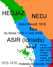
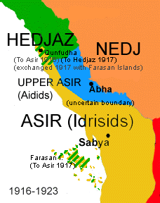
I think for Asir states this region needs a slightly redraw. Btw, the Farasan Islands were highly disputed between Britain and Italy in the years around 1900-1945 because it was believed that there was oil (which were proved as wrong later). The control of this islands changed a lot. During Ottoman control Germany was given concession to built a coaling station.


Here I have some maps for you. As you can see there are differences between them. I have some academic scripts, so give me some days for researching. For now it is just a warning :P .


Image
Image
Image
Image
Image


Image
Image
Image
Image
Image


Image
User avatar
Arturius
Administrator
 
Posts: 459
Joined: Wed 15. Feb 2012, 14:20
Location: Erfurt, Germany

by Advertising » Tue 15. Jan 2013, 04:18

Advertising
 

Re: Asir

Postby Arturius » Tue 15. Jan 2013, 17:32

Territorial history of controlled area by Muhammad al-Idrisi ('Lower Asir')

1872 - Yemen was made Ottoman vilayet (province) and was divided into four sanjaks (districts). Asir was one of them.
1906 - Muhammad al-Idrisi returns to Sabya and was gaining control in and around Sabya
1910 - After Muhammad al-Idrisi occupied settlements from Ottoman rule in summer 1909. In October 1909 Ottomans started negotiations with Muhammad. Agreement of al-Hafair was settled, which was executed in June 1910: Asir kept under supreme rule of Ottoman Empire as district. Muhammad was made qaimaqam of Sabya and therefore gained authority of a part of Asir (from Samita in the south to Hali in the north).
1913 - In December 1910 Muhammad again started a revolt which lasted until outbreak of Balkan War. Negotiations were held. Ottomans offered limited autonomy and an extension southwards except Farasan. Muhammad wanted control over Midi, Farasan and Gizan and full independence. The negotiations were abandoned. In August 1914 Muhammad sued for peace but the start of First World War gave him rest period, so that he was able to continue fighting the Ottomans in 1915.
1916 - Coastal town al-Qunfud which was occupied by Muhammad was transferred to Hejaz.
1917 - Britain transfered control of Farasan Islands to Muhammad
1918 - Britain transfered al-Luhayya to Muhammad.
1920 - Treaty between Ibn Saud (ruler of Nejd) and Muhammad signed which settled spheres of control (Abha, Muha'il, Bariq to Nejd)
1921 - Britain surrendered the town Hudaydah to Muhammad.
1926 - Muhammad died 1923, first his son Ali, later his brother Hasan became the ruler of Lower Asir. Yemen attacked Asir and annxed Gizan. Asir became protectorate of Nejd.
1930 - Asir was annexed by Saudi-Arabia (former Nejd)
1933 - Revolt of Hasan in Sabya and Gizan against Saudi rule was defeated. From 1927 on there were several negotiations between Yemen and Saudi Arabia to settle territorial disputes. When Hasan fled to Yemen after his failed revolt in 1933, Yemen invaded (Saudi–Yemeni War). The war ended in 1934.


Territorial history of controlled area by Hasan bin Ali al-Aid ('Upper Asir')

Note: Further researching is needed. I found several dates when Hasan came to power, when he revolted and when he was finally defeated.

1912 - Hasan bin Ali is made qaimaqam of Abha, one qada of Asir
1918 - Ottoman garrison left Abha due to defeat of Ottoman Empire. Hasan became independent ruler of Abha.
1920 - Hasan was defeated by Ibn Saud. Abha became part of Nejd.
1922 - Hasan revolted but was defeated again.
User avatar
Arturius
Administrator
 
Posts: 459
Joined: Wed 15. Feb 2012, 14:20
Location: Erfurt, Germany

Re: Asir

Postby Arturius » Tue 15. Jan 2013, 18:07

Here are the relevent maps sorted. I have taken those maps that according to my research are the right one. I relinquished the representation of Muhammad's controlled territory from 1906-1909 because of small size ('control in and around Sabya'). I think with this distribution of provinces all territorial changes mentioned above would representable. If you have any question please ask.


1. Ottoman administration:

1.1 sanjak Asir

area filled with blue colour

Image


Here you can see which cities were part of sanjak Asir ('Sangaq Asir'):

Image


1.2 qada Sabya = Lower Asir in 1909


The coast can be merged and must not be separated.

Image


1.3 qada Abha = Upper Asir 1918-1920/22

area filled with light green colour

Image


2. Idrisi Asir gains from 1917-1921:

1913/15 Gizan (green)
1917 Farasan (uncoloured)
1918 al-Luhayya (pink)
1921 al-Hudeida (blue)

Image


3. Al-Qunfuda

Al-Qunfuda was part of sanjak of Asir but claimed by several factions (by Hejaz, by Nejd and by Muhammad) until 1915. Then it was occupied by Muhammad and transfered from his control to Hejaz' in 1916.

dotted lines

Image
User avatar
Arturius
Administrator
 
Posts: 459
Joined: Wed 15. Feb 2012, 14:20
Location: Erfurt, Germany

Re: Asir

Postby Arturius » Wed 16. Jan 2013, 18:14

And I'm open for countersuggestions of course.
User avatar
Arturius
Administrator
 
Posts: 459
Joined: Wed 15. Feb 2012, 14:20
Location: Erfurt, Germany

Re: Asir

Postby Arturius » Sun 20. Jan 2013, 15:52

ok, I'm able to give you concrete suggestions soon
User avatar
Arturius
Administrator
 
Posts: 459
Joined: Wed 15. Feb 2012, 14:20
Location: Erfurt, Germany

Re: Asir

Postby mumia » Mon 21. Jan 2013, 22:23

No problem, there are still some time to next E3Map release. When you'll have all suggestions completed I'll compare them with current Asir setup. Also if you have any other suggestions regarding that region, for example Oman or Hedjaz, please post them.

Here is a map I used as base for current Arabia setup:

Image
mumia
 
Posts: 155
Joined: Wed 15. Feb 2012, 18:52
Location: Dąbrowa Górnicza (Zagłębie Dąbrowskie), Poland

Re: Asir

Postby Arturius » Wed 23. Jan 2013, 22:08

mumia wrote:No problem, there are still some time to next E3Map release. When you'll have all suggestions completed I'll compare them with current Asir setup. Also if you have any other suggestions regarding that region, for example Oman or Hedjaz, please post them.


Oh yes, I will take that chance! Needs only some time for researching, yeehae!
User avatar
Arturius
Administrator
 
Posts: 459
Joined: Wed 15. Feb 2012, 14:20
Location: Erfurt, Germany

Re: Asir

Postby Arturius » Sat 16. Feb 2013, 23:36

Image


Note that you have differ between the Ottoman province Asir and the independent emirates which were controlled by Idrisids and the Aidids. Those emirates controlled only some districts of Asir (Idrisids: Sabya [in core], Aidids: Abha). For the borders between coastal provinces and hinterland provinces I took the mountains as measure.

1) Al-Qunfudhah

I have not considered the territorial exchange between Hejaz and Asir because of province's size.

2) Sabya
3) Farasan Islands
4) Jizan (not only releveant for Idrisids' possession but also subject of Arab-Yemeni-War in 1934 and is disputed still today)
5) Al-Luhayya
6) Al-Hudeida
7) Ragdan (probably)

I've add this province. It was part of Ottoman Asir, but not part of the Idrisids whereas Al Qunfuda was. But I'm still not happy with.


I'm must confess I'm not happy with Al-

https://dl.dropbox.com/u/20512754/asir.xcf
User avatar
Arturius
Administrator
 
Posts: 459
Joined: Wed 15. Feb 2012, 14:20
Location: Erfurt, Germany

Re: Asir

Postby Arturius » Sun 24. Feb 2013, 20:59

The province of Hudeida should go down to Aden to make division from coast and highlands perfect.

Edit: Ah wait, this would contrdict with Asir possession in 1919. Then from Hudaida to Aden a coastal province additionally?
User avatar
Arturius
Administrator
 
Posts: 459
Joined: Wed 15. Feb 2012, 14:20
Location: Erfurt, Germany

Re: Asir

Postby mumia » Mon 25. Feb 2013, 18:15

Asir - Yemen in conclusion:

Image

- red lines - new borders
- green lines - removed borders
1. Ta'izz
2. Ibb - new province
mumia
 
Posts: 155
Joined: Wed 15. Feb 2012, 18:52
Location: Dąbrowa Górnicza (Zagłębie Dąbrowskie), Poland

Next

Return to E3 Map Project

Who is online

No registered users

cron