E3Map for Darkest Hour


Moderator: mumia

Re: E3Map for Darkest Hour

Postby Arturius » Thu 27. Sep 2012, 17:23

I need some info about settlements in north coastal areas of Northern Territory (Arnhem Land and Barkly Tableland) and West Australia (Kimberley Plateau)


What exactly do you need to know? What areas were settled? Or do you need names for provinces?
User avatar
Arturius
Administrator
 
Posts: 459
Joined: Wed 15. Feb 2012, 14:20
Location: Erfurt, Germany

by Advertising » Thu 27. Sep 2012, 17:23

Advertising
 

Re: E3Map for Darkest Hour

Postby mumia » Thu 27. Sep 2012, 19:36

Province names are needed, even smallest aboriginal settlements would be OK.
mumia
 
Posts: 155
Joined: Wed 15. Feb 2012, 18:52
Location: Dąbrowa Górnicza (Zagłębie Dąbrowskie), Poland

Re: E3Map for Darkest Hour

Postby Arturius » Fri 28. Sep 2012, 16:54

Image


1) Port Keats
2) Rakula
3) Darwin or Palmerston
4) Milingimbi
5) Yirrkala
6) Borraloola
User avatar
Arturius
Administrator
 
Posts: 459
Joined: Wed 15. Feb 2012, 14:20
Location: Erfurt, Germany

Re: E3Map for Darkest Hour

Postby mumia » Sat 29. Sep 2012, 13:59

Thank you, Arturius. By the way, provinces 1 and 2 were planned to be one province. Also I need a name for that big province between 3, 4, 5 and 6 (hilly part of central Arnhem Land), none of my maps show any settlement in 1936 there, but I suppose Australian Aborigines lived there.
mumia
 
Posts: 155
Joined: Wed 15. Feb 2012, 18:52
Location: Dąbrowa Górnicza (Zagłębie Dąbrowskie), Poland

Re: E3Map for Darkest Hour

Postby Arturius » Sat 29. Sep 2012, 16:02

ok, 1) + 2) would be Port Keats. I have two maps, one from 1914 and one from 1938. There was nothing. Would Oenpelli be part of this area? I fear that not.

Image
User avatar
Arturius
Administrator
 
Posts: 459
Joined: Wed 15. Feb 2012, 14:20
Location: Erfurt, Germany

Re: E3Map for Darkest Hour

Postby Arturius » Sat 29. Sep 2012, 16:11

Ah wait, there are settlements in southern Arnhem land called 'Bulman' or 'Weemol' which are part of land called 'Ngarrbun' I cannot confirm that these settlements existed before 1945, but the land name should fit.

Image
User avatar
Arturius
Administrator
 
Posts: 459
Joined: Wed 15. Feb 2012, 14:20
Location: Erfurt, Germany

Re: E3Map for Darkest Hour

Postby mumia » Sat 29. Sep 2012, 18:01

OK, so maybe I'll use Bulman till I find anything better.
mumia
 
Posts: 155
Joined: Wed 15. Feb 2012, 18:52
Location: Dąbrowa Górnicza (Zagłębie Dąbrowskie), Poland

Re: E3Map for Darkest Hour

Postby Arturius » Sat 6. Oct 2012, 18:55

One suggestion to redraw provinces of Eastern Aden:


Image


And if you have some extra time available could seperate Aden?

Image
User avatar
Arturius
Administrator
 
Posts: 459
Joined: Wed 15. Feb 2012, 14:20
Location: Erfurt, Germany

Re: E3Map for Darkest Hour

Postby mumia » Sun 7. Oct 2012, 10:55

Should I add separate province for Upper Yafa? I can increase a little its size if needed. About Aden, do you mean I should make it a small coastal province in size lets say of Hong Kong province?
mumia
 
Posts: 155
Joined: Wed 15. Feb 2012, 18:52
Location: Dąbrowa Górnicza (Zagłębie Dąbrowskie), Poland

Re: E3Map for Darkest Hour

Postby Arturius » Sun 7. Oct 2012, 12:33

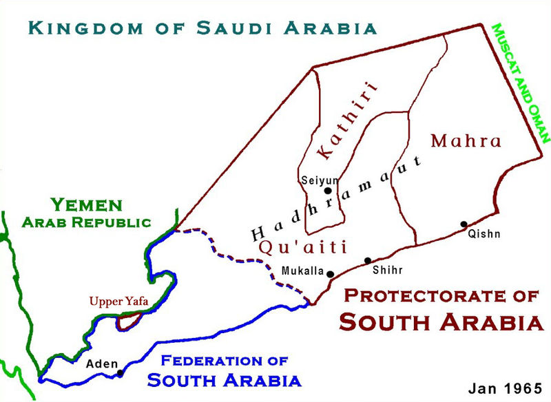
mumia wrote:Should I add separate province for Upper Yafa? I can increase a little its size if needed.


No, from my side Yafa is not needed. I really mean only the shape of the Eastern provinces.

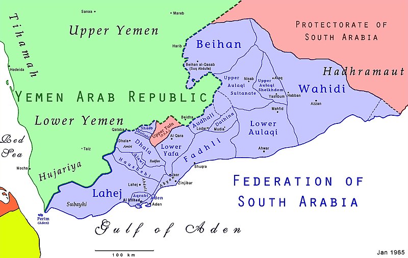
mumia wrote: About Aden, do you mean I should make it a small coastal province in size lets say of Hong Kong province?


Yes, exactly. :)


Btw, Aden was called ‘arsehole of the empire’, because everything went through it.
User avatar
Arturius
Administrator
 
Posts: 459
Joined: Wed 15. Feb 2012, 14:20
Location: Erfurt, Germany

PreviousNext

Return to E3 Map Project

Who is online

No registered users

cron